historians.social is one of the many independent Mastodon servers you can use to participate in the fediverse.
Historians.social is open to all who are interested in history.

Server stats:

235
active users

#mercator

0 posts0 participants0 posts today

Mercator Misconceptions - Clever Map Shows the True Size of Countries [Especially In High Latitudes]
--
visualcapitalist.com/mercator- <-- shared technical article
--
equal-earth.com/ <-- shared Equal Earth map projection details [the poster’s recommended global projection for many use cases]
--
[note the ‘true’ size of high latitude landmasses like Greenland and Canada (and Russia as well); note also that the Mercator Projection was not / is not a ‘tool of colonialism’, geopolitics or the like, it was/is ‘simply’ a very clever projection to aid in marine navigation]
#GIS #spatial #mapping #projection #Greenland #Canada #Russia #size #landarea #projection #mapprojection #JustSayNoToGallPeters #equalarea #Mercator #marine #nautical #navigation #spheroid #globe #area #shape #direction #equalearth #Africa #rhomb #rhomblines

A #map in the #wild. Turned around this evening in the #pub #urinal (not before I’d finished!) to see this peeling #wall paint. Can you see a #Mercator northern hemisphere #global projection here? It struck me immediately!

FYI I hate Mercator projections. If I’m forced to put #north at the top of my maps, then I choose #EqualEarth projections. I disavow Mercator’s #imperialist #global view of the world. As a #medieval (ist) #East is always top of any map I draw anyway! #Orientate your #Maps.

Happy birthday to Gerardus Mercator (1512-1594) renown Flemish cartographer.

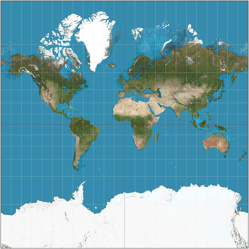
What made Mercator a great #cartographer, was in fact his abilities as a #mathematician -and like those of us scientists who feel compelled also to create art he was wasn't hindered by his immense ability as an engraver. He produced beautiful world maps (a version of which is depicted in this print), globes, 🧵1/n

Hey map people:

**Has anyone come across any interesting reading (thinkpieces, academic work, etc.) about the resurgence of the Mercator projection in the tiled map era?**

I'm interested to know if folks have been discussing the potential impact of tiled Mercator on geographic perspectives in the general public. Or if there's been any talk about the more recent reintroduction of orthographic and spherical views by Google/Apple/etc. at low zoom levels.